About EAPs
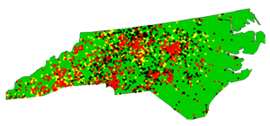
Where are High-Hazard Potential Dams?
Residents near
a High-Hazard
Potential dam
should find
out if it has
an Emergency
Action Plan.
This list is updated each year and provided to the U.S. Army Corps of Engineers for the National Inventory of Dams (NID). If you can locate a HHP dam near an area where you live, work, travel or have recreational activities, it is important that the dam have an Emergency Action Plan. Column Q identifies the town nearest to the dam. Compare column E (EAP) and column H (Hazard Potential). An N for EAP means no EAP has been filed. NR means the EAP is not required, and that designation generally is for Intermediate- or Low-Hazard Potential dams. Column AN provides the name of the owner of the dam.
When you know the county where a dam is located and a nearby town, using Geographic Information Systems (GIS) software such as Google Earth can often provide a "bird's eye view" of the area terrain. The website Lat-Long.com lists North Carolina dams and links locations to maps and satellite views. Using the map to zoom in on the impoundment and then the satellite image can provide more visual understanding of the terrain. Another helpful tool for determining whether an area is at risk is the North Carolina Floodplain Mapping website.
 Red Dots = "High-hazard potential dam" is typically defined as a dam whose failure or mis-operation will cause loss of human life and significant property destruction.
 Yellow Dots = "Significant-hazard potential dam" is typically defined as a dam whose failure or mis-operation will cause significant property damage.
Black Dots = "Low-hazard potential dam" is typically defined as a dam whose failure or mis-operation will cause minimal property damage.
Knowing where a HHP dam is located that may impact your home, business, or favorite recreational area is important. But knowing the boundaries of the "hazard area" also is important. This information may not be clearly defined unless there is an EAP for that dam. A thorough EAP will include an "inundation map" that shows the hazard area.
A major factor in concern about dam safety and the need for EAPs is the age of many dams. Hundreds of the dams are known to have been built prior to 1950, and the construction date for hundreds more is unknown.
Many dams become a greater hazard as they continue to age and deteriorate. While hundreds of them need to be rehabilitated, lack of funding prevents the work. Even dams that fall under state regulation can be a problem when ownership of the dam is unknown and rehabilitation is likely to be costly.
