About EAPs
Where are High-Hazard Potential Dams?
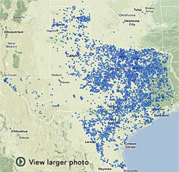
HHP dams are scattered across Texas, but tend to cluster around population centers and areas where the land is more amenable to building dams (see map below).
The Texas Dam Safety Program develops a list of dams that includes details as to their location, ownership, hazard classification, EAP status, etc. This list is continually updated and provided to the U.S. Army Corps of Engineers for the National Inventory of Dams (NID). Parts of the Corps NID website now are password-protected for national security reasons. In recent years some of the Texas dam information has been withheld from the public by Texas Commission on Environmental Quality (TCEQ) in compliance with provisions of the Texas Homeland Security Act of 2003 and a February 2005 state attorney general’s opinion that hazard classifications and EAPs are exempt from disclosure under the state's Public Information Act.
The Dam Safety Program can provide a list of all the dams in a county, but it will not state the hazard classification. An independent website, lat-long.com, also provides a list of Texas dams by county. Their hazard classification is not listed. Clicking on the name of the dam will bring up a map and satellite image of its location. Using the map to zoom in on the impoundment and then the satellite image can provide more visual understanding of the terrain. Google Earth also may be helpful in examining an area of interest to see whether a significant dam and impoundment may be within a few miles.

Locatons of dams in the state of Texas
The Texas Water Development Board has links to floodplain maps that also can provide understanding of risk in specific areas. These include the Federal Emergency Management Agency (FEMA) Map Service Center.
If you can locate a HHP dam near an area where you live, work, travel or have recreational activities, it is important that the dam have an Emergency Action Plan. The only recourse may be to phone the Dam Safety Program office (512-239-5195) and ask about the EAP status of a dam that is of concern. Contact information for an owner may be available through the Dam Safety Program or by visiting the area of the dam. Access to the dam itself should be prohibited.
Knowing where a HHP dam is located that may impact your home, business, or favorite recreational area is important. But knowing the boundaries of the "hazard area" also is important. This information may not be clearly defined unless there is an EAP for that dam. FEMA Guidelines for EAPs state that an inundation map is one of the six basic elements needed in an EAP.
A major factor in concern about dam safety and the need for EAPs is the age of many dams. The National Inventory of Dams information on Texas notes that 275 of the state’s dams were built before 1900, and another 841 predate 1950, after which 1,069 were build in the 1950s. Another 2,755 were built during the 1960s, which was when many USDA conservation programs assisted in funding hundreds of dams. These NRCS project dams are under state regulation and are regularly inspected. Many dams become a greater hazard as they continue to age and deteriorate. While hundreds of them need to be rehabilitated, lack of funding prevents the work. Another problem that complicates rehabilitation efforts, along with EAP compliance, is that the ownership of some older dams is not known or uncertain.
