News & Events
News & Events
In The News
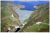
Castaic Dam undamaged by earthquake
1-5-15 | Santa Clarita Valley Signal | By Jim Holt
Castaic Dam was undamaged by the earthquake that occurred just a few miles north of the body of water on Saturday, officials said Monday.
"I talked with our southern field personnel and they tell me they conducted a complete inspection of Castaic Dam and found no damage," said Shawn Jones, southern regional field engineer for the state's Division of Safety of Dams.
Safety officials also inspected Pyramid Dam on Piru Creek, north of Castaic, and found no damage, he said.
The earthquake struck at 7:18 p.m. Saturday about six miles north of Castaic Dam. It measured 4.2 on the Richter Scale and was one of several local temblors to hit as part of an earthquake swarm, California Institute of Technology seismologist Kate Hutton said Saturday. read more
...................................
EPA coal ash standards a setback for environmental groups
12-20-14 | Raleigh News & Observer | By Dylan Lovan, Travis Loller and Dina Cappiello, Associated Press
NASHVILLE, Tenn. — Six years ago, there was a massive spill of coal ash sludge in Tennessee. Three years later, tons of coal ash swept into Lake Michigan. Last February, there was another spill and gray sludge spewed into the Dan River in North Carolina.
With each disaster, environmentalists sounded alarms and called for the byproduct of burning coal to be treated as hazardous waste. On Friday, U.S. Environmental Protection Agency released the first standards for the coal-burning waste, but they were hardly what environmental groups were hoping for.
The EPA ruled that the ash can be treated like regular garbage, meaning regulating the stuff will be left up to states and watchful citizens.
"We had to go to court to force EPA to issue this first-ever coal ash rule, and unfortunately, we will be back in court to force coal plants to clean up their ash dumps and start disposing of their toxic waste safely," said EarthJustice attorney Lisa Evans.
Added Scott Slesinger of the Natural Resources Defense Council: "Unlike the majority of environmental standards — which are backstopped by federal enforcement — this rule all but leaves people who live near coal ash dumps to fend for themselves." read more
...................................
EPA won't regulate coal ash as hazardous waste
12-19-14 | Raleigh News & Observer | By Bruce Henderson
The first federal rules on coal ash from power plants, released Friday, set the bar generally lower than North Carolina did in responding to Duke Energy's February spill into the Dan River.
The Environmental Protection Agency said it will regulate coal ash as solid waste, such as municipal garbage, instead of as a hazardous waste. Ash contains elements that can be toxic in water.
That decision leaves it to utilities to comply with the new federal rule, without federal enforcement. States can adopt similar standards if they choose, but enforcement is otherwise left to citizens by filing lawsuits.
"It's good that EPA is setting the first national standards for groundwater monitoring and cleanups," said Eric Schaeffer, a former EPA enforcement chief now at the Environmental Integrity Project. "But we're concerned that it relies too much on industry self-policing."
Industry groups praised the federal decision, saying the designation as non-hazardous would continue to make ash available for reuse in products such as concrete. Environmental advocates said EPA missed a chance to rein in a waste that's known to contaminate water.
The federal rule requires groundwater monitoring and says contaminating ash ponds have to be closed. It sets design, siting and inspection standards for ash ponds or landfills, including protective liners for new ones.
North Carolina's law, which took effect in September, bans new ash ponds and closes existing ones over 15 years. It expands groundwater monitoring, already underway, that has found contamination at each of Duke's 14 North Carolina power plants.
Unlike the EPA rule, the state doesn't allow inactive ash ponds to be capped without further study of their environmental impacts.
Industry practices and some state standards already eclipse the EPA in some ways, said Frank Holleman, an attorney with the Southern Environmental Law Center, which has filed citizen lawsuits against Duke.
"This is not the industry standard, but the industry minimum," Holleman said of the federal rule.
read more
...................................
December 23 Marks 50th Anniversary of Lower Hell Hole Dam Failure
Anniversary highlights need for emergency planning
12-16-14 | Association of State Dam Safety Officials
On December 23, 1964, after five days of heavy rainfall, the partially completed Lower Hell Hole Dam failed, causing 30,000 acre-feet of water and 700,000 cubic yards of rock to surge 60 miles down the Rubicon River canyon before terminating into Folsom Lake four hours later.
The Lower Hell Hole Dam, located about 70 miles east of Sacramento, California, was designed as a 410-foot high zoned rockfill structure. During the first year of construction, progress was slower than anticipated, and the dam was only completed to a height of 220 feet before the start of the flood season. In late December 1964, record rainfall of 22 inches over five days filled the reservoir, causing the incomplete dam to fail.
Thankfully, no one was killed as a result of the failure, but rock from the failed dam was carried downstream for miles and five bridges, including two suspension bridges and the California Highway 49 bridge over the American River, were washed out before the water flowed into the Folsom Reservoir. The lack of more severe consequences can be attributed to the remote location of the reservoir as well as the event occurring during a time of the year when downstream recreational use was low. read more
...................................
Carmel River diverted to demolish San Clemente Dam
12-14-16 | San Francisco Chronicle | By Peter Fimrite
CARMEL VALLEY, Monterey County — The Carmel River had just begun flowing after the recent rains, prompting Lorin Letendre and several others to hike up to a ridge above the San Clemente Dam in Monterey County this past week to see the surging stream.
Letendre, the president of the Carmel River Watershed Conservancy, was not so interested in the forested slopes of the Santa Lucia Mountains as he was the tableau of human engineering that stretched out before him. The entire Carmel had been diverted into a man-made river bed — an unusual and, in his eyes, strangely successful attempt to improve on nature.
"You are seeing the first time the river has come into its new channel," declared Letendre, pointing from the overlook down to a giant raw notch cut out of a mountain where the river was flowing. "This is just an incredible historic moment seeing the river coming through on its new course."
The channeling of the Carmel last week into a carefully engineered river bed was designed to bypass the tons of sludge behind the 106-foot-tall San Clemente Dam, which has blocked both the river and San Clemente Creek for 94 years. The new river channel will allow workers to take down the dam structure next year without worrying about a catastrophic mudslide.
The diversion, which includes the restoration of an entire river ecosystem, is the largest, most innovative dam removal project ever attempted in California.
The $83 million dam removal plan may be a surprise to some, given the recent dry weather, but regulators say it is necessary. The San Clemente Reservoir is 95 percent full of mud and was declared a seismic hazard by the California Department of Water Resources' Division of Safety of Dams as far back as 1992. It has been out of commission since 2002.
The dam, left alone, was a calamity waiting to happen, according to regulators, who said 1,500 homes and numerous businesses downstream would be in danger from cascading water and mud if there was a collapse. read more
...................................
Earth Log: It's nitty-gritty time for Temperance Flat funding
11-24-14 | The Fresno Bee "Earth Log" | By Mark Grossi
This isn't over. The San Joaquin Valley campaign for Temperance Flat Reservoir may have moved forward on federal drawing boards, and it may have gotten a shot of adrenaline when the $7.5 billion water bond past this month.
But the public money is not committed here yet. Instead, a spotlight has suddenly appeared on the California Water Commission, a seemingly obscure, nine-member board.
These are the folks who will have a lot of say about spending $2.7 billion of bond – the water storage investment in this measure. They will decide which projects have enough public benefit to be funded.
In the Valley, the top of that pyramid of projects would be Temperance Flat Reservoir, upstream of Millerton Lake. So the campaign continues, probably for many months to come as the commission deliberates. There likely will be studies, announcements, media events – from many sides of the issue.
In the federal bureaucratic study process, Temperance Flat probably will have a final Environmental Impact Statement in the coming months.
The University of California at Davis is advising the state to look at storage projects as part of the larger picture of water use and needs in California, not in isolation. The study is called "Integrating Storage in California's Changing Water System." Consider it one of the starting places for the funding discussion, at least as far as UC Davis is concerned. read more
...................................
Take time to check for Napa earthquake damage before disaster assistance deadline Dec. 29
11-18-14 | FEMA News Release
SACRAMENTO, Calif. – When earthquakes occur, some of the damage happens in areas of our homes and businesses that may be nearly impossible to spot without close attention. Residents and business owners in Napa and Solano Counties continue to discover damage from the South Napa Earthquake.
The California Governor's Office of Emergency Services (Cal OES) and the Federal Emergency Management Agency (FEMA) urge people in those counties to take time to check for any signs of potential damage and register for assistance as soon as possible.
"Earthquake damage sometimes goes unnoticed," said Federal Coordinating Officer Steve DeBlasio. "Earthquakes are different from other disasters, because damages can mimic regular wear and tear or be so subtle that they are hard to find at first. A new crack or stuck door, for example, could be the sign of a serious problem."
Homeowners and renters in Napa and Solano Counties who had damage from the South Napa Earthquake have until Dec. 29, 2014 to apply for disaster assistance from FEMA. Disaster assistance includes grants to help pay for temporary housing, essential home repairs and other serious disaster-related needs not covered by insurance or other sources.
Cal OES and FEMA offer the following questions and tips to help everyone spot potential damage:
Exterior Structure:
- Has the house shifted off its foundation? Has it fallen away from the foundation in any place?
- Is the structure noticeably leaning? When looked at from a distance, does it look tilted?
- Do you see severe cracks or openings between the structure and outdoor steps or porches?
- Do you experience seriously increased vibrations from passing trucks and buses?
- Do you see severe cracks in external walls or foundation?
- Are there any breaks in fence lines or other structures that might indicate nearby damage?
- Did you check for damage to ceilings, partitions, light fixtures, the roof, fuel tanks and other attachments to the main frame of the structure?
Chimneys:
- Are there cracks between the chimney and the exterior wall or the roof?
- Are there cracks in the liner?
- Did you find unexplained debris in the fireplace?
Utilities:
- Are power lines to your house noticeably sagging?
- Is your hot water heater leaning or tilted?
- Are all the water connections secure including those for pipes, toilets, faucets?
Interior:
- Are any doors and windows more difficult to open or close?
- Is the roof leaking? Is there water damage to the ceiling?
- Has the furnace shifted in any way? Are ducts and exhaust pipes connected and undamaged?
- Do you feel unexplained draftiness? Are any cracks in the walls, poorly aligned window frames or loosened exterior sidings letting in breezes?
- Has the floor separated from walls or stairwells anywhere inside the house?
- Are there cracks between walls and built-in fixtures such as lights, cupboards or bookcases?
- Does the floor feel "bouncy" or "soggy" when you walk on it?
- Have you checked crawl spaces, stairwells, basements, attics and other exposed areas for signs of damage such as exposed or cracked beams, roof leaks and foundation cracks?
Damage inspections by FEMA are free and generally take 30 to 45 minutes, and they are conducted by FEMA contract inspectors who have construction or appraisal expertise and have received disaster-specific training. Inspectors document the damage by checking the building structure and its systems, major appliances and any damaged septic systems and wells.
If applicants discover additional damage to their property after the inspection takes place, they can request another one. Additional information on California disaster recovery is available at www.fema.gov/disaster/4193. read more
...................................
Farm leaders celebrate water bond passage, prepare for round two
11-7-14 | Fresno Bee | By Mark Grossi
Farm water officials worked years on the $7.5 billion state water bond that passed Tuesday, offering the possibility of partly bankrolling a new reservoir near Fresno. Now it's time for round two – actually getting funding for Temperance Flat and other projects.
At the Fresno Irrigation District Thursday, farm water officials joined the California Latino Water Coalition in announcing they would continue pushing for the projects next year at the California Water Commission in Sacramento. The commission will allocate $2.7 billion for water storage projects, based on public benefit, and there will be competition for the money.
A new dam at Temperance Flat, upstream of Millerton Lake, would nearly triple the storage capacity. Critics say there's not enough water coming from the San Joaquin River to justify the dam, but farm water officials say the storage is needed to capture water in wet years.
The debates now will shift to the California Water Commission, which has nine members. Two are from the San Joaquin.
Farm water officials say that if a larger reservoir had been built upstream of Millerton, it could have captured water from a previous wet year and eased the drought for 15,000 east Valley farmers in the Friant Water Authority. In addition, the underground water table continues to drop dramatically, leaving hundreds of private well owners dry. More water in a reservoir would mean more water to recharge the underground, officials said. read more
...................................
County will welcome water bond money
11-5-14 | Visalia Times Delta | By David Castellon
Tulare County farmer Dennis McFarlin was happy that California voters passed a $7.5 billion water bond on Tuesday.
But one concern he has is how much of that money, intended to fund project to improve water storage and water quality across the state, will actually end up paying for brick-and-mortar projects here in Tulare County and other parts of the South Valley.
McFarlin thinks part of that money should go to finally build the Temperance Flat Dam on the San Joaquin River, upstream from the dam at Millerton Lake.
That in turn, would improve water storage, making more available for farms and communities that get surface water via the the Friant-Kern Canal, which extends from below Millerton, in Fresno County through eastern Tulare County and into Kern County.
Some who have waited for the state bond measure to finally be passed are optimistic a good chunk of the money will benefit Tulare County.
Several irrigation and water conservation districts in the South Valley already have plans to construct new ponding basins to capture water during storms and percolate it underground.
Ronald Jacobsma, general manager of the Friant Water Authority, which oversees the distribution of water from Millerton Lake, noted that in some cases, even with Prop. 1 money communities may have to come up with additional dollars for projects.
For example, if it can be shown that building Temperance Flat Dam provides a public benefit in terms of flood protection, recreation opportunities, protecting wildlife and providing an emergency water supply, Prop. 1 money might be able to pay for up to half of the dam's projected $2.5 billion cost.
There are four other proposed dam and water-storage projects that likely will be vying for portions of the Prop. 1 dollars. read more
...................................
Temperance Dam plan is flawed, critics say at Fresno forum
10-16-14 | The Fresno Bee | By Mark Grossi
Auberry resident Shannon Lodge told federal officials Thursday that a new Temperance Flat Reservoir would swamp a gem of an outdoor recreation area upstream of Millerton Lake — and the property where she lives.
"My grandmother is buried on that property," she told the U.S. Bureau of Reclamation as she commented in opposition to the proposed $2.6 billion project.
About 100 people listened at a public meeting in Fresno to sometimes passionate statements from speakers who faulted everything from the feasibility analysis to the notification for the hearing on the draft Environmental Impact Statement for Temperance Flat Reservoir.
About a decade after beginning the investigation of a larger reservoir on the San Joaquin River, federal leaders have entered the final stages of their work to complete a plan that would have to be approved by Congress.
The Bureau, owner and operator of Friant Dam at Millerton Lake, will consider comments given this week. The deadline for written comment is Tuesday. A final Environmental Impact Statement is expected in the next several months.
The draft environmental review says Temperance Flat Reservoir would be built 6.8 miles upstream of Friant Dam near Fine Gold Creek, partially inside the back end of 520,000 acre-foot Millerton Lake.
It would add a net 1.26 million acre-feet of storage. Each 326,000-gallon acre-foot would supply an average San Joaquin Valley family for a year to 18 months. read more
...................................
Environmentalists divided over water projects
10-2-14 | Modesto Bee | By Michael R. Blood Associated Press
LOS ANGELES — A proposal on the November ballot to borrow billions of dollars to build reservoirs and restore watersheds has divided California's environmental community over fears that it could open the way for salmon-killing dams or giveaways to corporate fruit and nut growers.
The rise of organized opposition to what's known as Proposition 1 comes about a month before the election, with independent polls showing voters favoring the blueprint that is one of Gov. Jerry Brown's signature initiatives.
It's "a bad deal for California taxpayers and won't solve California's water problems," said Adam Scow, state director of Food & Water Watch, which staged a protest against the proposition Thursday in Beverly Hills.
"When you have 1,400 dams in California, pouring concrete to make ... new dams ain't going to make it rain," he said.
If enacted by voters Nov. 4, the proposal would authorize $7.5 billion in borrowing for an array of projects as California struggles through a punishing drought and record heat.
Supporters argue that the plan is vital at a time of scarce rain, when water reserves are drying up. Some of the state's leading environmental voices, including the California League of Conservation Voters and the Natural Resources Defense Council, have endorsed it. read more
...................................
Tribe protests plans to raise dam
9-15-14 | Blue Mountain Eagle | By Tim Hearden
California Native Americans protest plans to raise the dam at Shasta Reservoir.
SHASTA LAKE, Calif. — A local tribe showed its displeasure with a proposal to raise Shasta Dam here by holding a four-day fast and ceremonial war dance beginning at dusk Sept. 11.
Members of the Winnemem Wintu Tribe contend the proposal, which the U.S. Bureau of Reclamation could unveil by the end of this year, would cause more of their historical lands along the McCloud River to be flooded.
"We're a traditional tribe — we believe in our ceremonies and we believe in the sacred," said Caleen Sisk, chief of the tribe based in Redding, Calif. "We're telling the sacred places and the river that we're doing everything we can to bring the salmon back and help the waters."
The Winnemem say they lost much of their homeland and their salmon when the dam was first constructed, and any raising would threaten to submerge many of their sacred sites and village areas.
Once the proposal has gone through reviews, U.S. Interior Secretary Sally Jewell will present a proposal to Congress, which will determine the project's feasibility and funding, Moore said.
A series of workshops and hearings on the proposals was held last year and comments were taken, and the document addresses cultural concerns as required by federal environmental law, he said. A preliminary study in 2011 acknowledged that cultural impacts from the project would be "significant," as the Wintu have identified areas where ceremonies are still conducted as well as some 155 ancestral villages within the Shasta Lake area. read more
...................................
Letter-writing campaign aims to memorialize St. Francis Dam site
9-13-14 | Santa Clarita Valley Signal | By Mason Nesbitt
Two floods — one in the Santa Clarita Valley — occurred 2,500 miles and 39 years apart. But both resulted from failed dams and both devastated their regions: one killing more than 2,000 people, and the other roughly 600.
The site of one failed dam — in Johnstown, Pa., in 1889 — is a national memorial. The other — the St. Francis Dam disaster in San Francisquito Canyon in 1928 — is a sometimes-forgotten pile of rubble.
Alan Pollack, president of the Santa Clarita Valley Historical Society, wants residents to join a letter-writing campaign urging Congress to designate the St. Francis Dam site a national memorial, too.
The St. Francis Dam opened in 1926 and failed on March 12, 1928. The resulting flood swept down San Francisquito Canyon and across much of the rest of the Santa Clarita Valley. The water swept down the Santa Clara River Valley, wiping out all or parts of Castaic Junction, Piru, Fillmore, Saticoy and Santa Paula.
It killed approximately 600 people, according to a government document. read more
...................................
Shaken and stirred in California's recent earthquake.
How seismic events can make drought impacts worse.
9-1-14 | High Country News | By Jeremy Miller
At first glance, the 6.0-magnitude earthquake that struck near Napa, California last Sunday seems to have little connection to the state's "other" major unfolding disaster — the drought. But, in fact, the two are closely linked and illustrate California's precarious reliance on a complex network of water infrastructure stretching across the state.
The day after the quake, inspectors from the Army Corps of Engineers and Bureau of Reclamation and local reclamation districts examined dams, canals and levees scattered across the area that experienced the heaviest shaking. They found no structural damage in the agency's facilities near the quake's epicenter, including the Coyote Valley Dam at Lake Mendocino and the Warm Springs Dam at Lake Sonoma. Inspections of a flood wall in Napa, which hems in the Napa River as it snakes through downtown, however, have revealed signs of cracking.
In spite of the dozens of injuries and extensive damage to homes, historic buildings and roadways – estimated to exceed $1 billion – things could have been much worse. Consider a scenario that has been imagined by experts for years: If Sunday's earthquake had occurred further to the east – nearer the tangled tidal channels in the heart of the Sacramento-San Joaquin Bay Delta – the resulting damage could compound tremendously the severity of the drought's effects.
That's because engineers and geologists say the more than 1,000 miles of earthen levees that interlace the Sacramento-San Joaquin Delta – source of irrigation water for millions of acres of Central Valley farmland and drinking water for more than 24 million Californians – are highly vulnerable to an earthquake. read more
...................................
California drought: Why doesn't California build big dams any more?
8-31-14 | San Jose Mercury News | By Paul Rogers
How much money drought-stricken California should spend to build new dams was a big part of the debate over the bill that Gov. Jerry Brown signed last month to put a $7.5 billion water bond on the November ballot.
New Melones Dam on the Stanislaus River near Sonora. (Bureau of Reclamation)
Republicans and Central Valley Democrats who pushed hardest for new reservoirs highlighted the fact that California built many of the world's most ambitious dam projects during the 1950s, 1960s and 1970s, but a large state- or federally-funded reservoir hasn't been built in 35 years.
But why did the era of big dams end, when California has built new roads, schools, universities, hospitals and freeways?
Experts say there is a confluence of factors, from environmental laws to funding to a lack of suitable sites. Now supporters of new reservoirs are trying to start a new dam-building era. read more
...................................
Next Earthquake Could Unleash Tsunami-Like Wave On Davis If Dam Fails
8-25-14 | KOVR-TV Sacramento
Predicting the next big earthquake seems to have become one part science with two parts guessing game.
UC Davis earthquake expert professor John Rundle says it's been quiet in the 25 years between the magnitude 6.9 Loma Prieta earthquake and Sunday's magnitude 6.0 Napa earthquake.
But he knows when Mother Nature ends her silence, she can come back with a roar.
The West Napa Fault has produced seven earthquakes since 1969. While that may not seem like much in the span of nearly half a century, the type of activity the line triggers—a strike-slip motion that triggers a sudden shift—has geologists worried.
That's because while the Napa earthquake alleviated pressure on one fault line, it may have added pressure to others nearby, including the Berryessa Fault which runs directory under the Berryessa Dam.
"And if that thing lets go and the dam fails, then a wall of water will come cascading through our area," he said. That's an area that includes Davis, which experts warn could get slammed with a wall of water up to eight feet deep. read more
...................................
USACE inspects dams following Napa quake
Lake Mendocino, Lake Sonoma checked
8-25-14 | Ukiah Daily Journal
U.S. Army Corps of Engineers-owned dams, including Coyote Dam in Ukiah, were inspected following the 6.0 earthquake near Napa and were found undamaged, according to the U.S. Army Corps of Engineers. The Corps engineers verified in site inspections Sunday and Monday.
Inspected Corps dams included Coyote Valley and Warm Springs dams, the nearest Corps dams to the earthquake's epicenter, managed by the Corps' San Francisco District; and New Hogan and
Farmington dams east of Stockton, managed by the Corps' Sacramento District.
Inspections of features of the Corps' flood risk reduction projects in Napa – including a floodwall and levee along the Napa River, Napa Creek culverts and ongoing oxbow bypass work – are still ongoing.
As a precaution, inspectors also verified the integrity of the Folsom Dam auxiliary spillway project Aug. 25, currently under construction in Folsom. read more
...................................
Napa Earthquake Raises Concerns About Sacramento's Levees
8-25-14 | KOVR-TV Sacramento
The Napa earthquake has prompted concerns in the Sacramento area about the stability of the region's levees in the instance of a larger temblor.
UC Davis scientists studied what would happen if a major earthquake hit along the Delta. The model shows a quake could wipe out sediment under the levees in a process called liquefaction. That would change the shape of a levee and reduce its ability to hold back water.
Darren Suen with the state FloodSafe program says no immediate threat has occurred, but that the levee is an area of concern. read more
...................................
Inside California's $7.5 billion drought-survival plan
8-19-14 | New Scientist | By Hal Hodson
The drought in California is a disaster unfolding in slow motion. The alarm was first sounded earlier this year as snowpack in the state's mountainous areas was far thinner than usual. Arid conditions have continued since, leaving reservoirs at record lows – cities are announcing usage limits for the first time in years, and farmers are rapidly draining water from underground aquifers just to stay in business.
The chance of a moisture-bringing El Niño climate event happening later this year, which some had looked to for salvation, has fallen from 80 to 65 per cent according to the latest forecasts.
Against this backdrop, governor Jerry Brown signed legislation last week that will allow California's voters to decide whether the state can spend $7.5 billion to address the problem. The bond will be spent on ensuring California's drinking water supply, improving groundwater management, boosting conservation and preserving the ecosystems that are being destroyed by the drought conditions. The vote is set for November.
Big spenders
The largest chunk of money, $2.7 billion, is slated for new water storage capacity, an essential resource if the state is to make it through long dry periods like the current one.
The California Department of Water Resources plans to spend the money on the proposed Sites reservoir, a 2.23-cubic-kilometre reservoir in the Sacramento valley. It will siphon off water from the Sacramento river in times of flood, saving it as a buffer for lean times. If built by 2019 as planned, the reservoir will be able to deliver up to 600 billion liters of water every year for drinking, agriculture, industrial use and preserving ecosystems in northern California.
The bill also designates $510 million to improve the state's water management, $100 million to boost water conservation, and $200 million to help capture and treat storm water run-off. read more
...................................
California dam under repair after cracking, prompting flood warning
8-14-14 | Los Angeles Times | By Veronica Rocha
A Northern California dam is under repair after it cracked Sunday and prompted nearby residents to panic as officials issued a flash-flood warning.
The National Weather Service issued the warning, which has since been canceled, after a portion of the Twain Harte Dam in Tuolumne County cracked and began leaking about 10:45 a.m.
But the cracks prompted concerns among residents who reported hearing a loud boom, according to Fox40.
Water had been leaking through the cracks, so officials began releasing about 2,000 gallons of water per minute from the lake, according to a Tuolumne County statement.
At the same time water from the 600-acre-feet capacity Phoenix Lake Reservoir was also released, so that it can take on new supplies from the lake, which is 20 to 25 deep and has 142-acre-feet capacity. read more
...................................
Yuba County officials: Flood watch was unwarranted
8-10-14 | KBET-TV Sacramento
A flood watch issued for Yuba County Thursday night by the National Weather Service and state officials was unwarranted, according to county authorities
The flood watch stemmed from concerns surrounding a spillway near a pond along Little Dry Creek. In a Facebook post Friday morning, the Yuba County Office of Emergency Services wrote that the spillway's failure is unlikely.
"The pond itself is privately owned and has been there for about 70 years," the office wrote in the post. "Yuba County OES agreed the integrity of the aging spillway needed to be addressed. so we brought in state and local agencies to help come up with a solution."
"(Unknown) to us, the State OES and Weather Service took it upon themselves to issue a Flood Watch -- we did not believe such a move was necessary," officials state in the post.
The post continues:
Yuba County OES did notify the handful of residences downstream from the pond, simply as part of our duty to keep the public advised in such situations. But everyone needs to understand that we have concluded that homes in the notified areas are built on higher ground and are not in danger of damage from flooding. Our concern is that -- in the unlikely event of a spillway failure at the pond -- children or others who are on the banks of the stream could be caught up in the initial rush of water.
The bottom line is that we view a spillway failure as unlikely. The work we are doing with the landowner will likely result in the needed repairs and enhance the safety of those in the area.
News10 is reaching out to state officials and the National Weather Service for comment. read more
...................................
San Diego Water Authority Dedicates Raised San Vicente Dam
7-17-14 | KPBS Radio News, San Diego | By Susan Murphy
A day after mandatory outdoor water restrictions were approved across drought-ridden California, nearly 200 San Diego leaders and community members gathered in East County to dedicate a vital increase to the county's water storage system.
The capacity of the San Vicente Reservoir in Lakeside was doubled in size after the dam was raised 117 feet; the dam is now 337 feet high.
The additional height will enable the region to capture more water during wet years to use in times of drought.
It's the final piece of San Diego County Water Authority's $1.5 billion emergency water storage system of reservoirs, interconnected pipelines and pumping stations, that will ensure the region has a six month supply of water in the case of an emergency or future drought.
"This super-sized San Vicente Dam holds an additional 152,000 acre feet of water storage for our region," said Maureen Stapleton, general manager of the Water Authority. "Fifty-two thousand acre feet will be held for emergency purposes only, and the additional hundred thousand acre feet will be used for what we call dry year or carry over storage,"
Filling the reservoir is expected to take two to five years depending on water supply availability and statewide demand. read more and hear audio
...................................
Santa Clarita City Council Requests St. Francis Dam To Be National Memorial
7-17-14 | KHTS Radio, Santa Clarita, CA | By Jessica Boyer
Santa Clarita City Council members requested that Congressman Howard P. "Buck" McKeon, R-Santa Clarita, consider introducing legislation to dedicate the St. Francis Dam Disaster of 1928 as a National Memorial.
The request came from the Santa Clarita Valley Community Hiking Club President Dianne Erskine-Hellrigel. The matter was referred to the City Council Legislative Subcommittee.
The City Council Legislative Committee officials met July 1 and considered the request, recommending that the Santa Clarita City Council officials and Santa Clarita Valley Community Hiking Club request McKeon to consider sponsoring legislation to "authorize a study to ascertain if the sites and events associated with the St. Francis Dam Disaster of 1928 meet the criteria for designation as a National Memorial, as a unit of the National Park Service," according to the city of Santa Clarita agenda report.
In addition to the dam site, officials are requesting that the wilderness areas surrounding the dam site be included in the memorial.
"The Community Hiking Club believes that it is appropriate to honor the individuals who lost their lives during the flood, as well as preserve the dam site and surrounding areas, through designation as a unit of the National Park Service," according to the agenda report.
Designating the site as a National Memorial protects the site to preserve for future generations.
No additional funds other than those provided in the fiscal year 2014-15 city budget are needed for the action of the site becoming a national monument, according to the agenda report.
The St. Francis Dam construction began in August 1924 and was completed in 1926 under the supervision of William Mulholland.
Today, the ruins of the dam are still visible when driving down the San Francisquito Canyon. Hikers, including the Santa Clarita Valley Community Hiking Club regularly visit the site, climbing to the top of one of the hillsides where the top of the dam still exists. read more
...................................
Updated Earthquake Map Shakes Up Risk Zones
7-17-14 | LifeScience.com, Louisville | By Laura Geggel
Parts of 42 states are at risk of earthquakes during the next 50 years, according to a new report from the U.S. Geological Survey.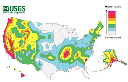
The report includes updated maps that show geologists' predictions of where and how often future earthquakes may occur, and how strongly they may shake the ground.
Many of the at-risk states are in the country's western half, but the map also highlights hotspots in the Midwest and Southeast.
There are 16 states that have regions labeled as being at high risk for seismic activity, because they have histories of earthquakes measuring a magnitude of 6.0 or greater: Alaska, Arkansas, California, Hawaii, Idaho, Illinois, Kentucky, Missouri, Montana, Nevada, Oregon, South Carolina, Tennessee, Utah, Washington and Wyoming.
In making the new maps, geologists considered data from earthquakes that have struck since the maps were last updated, in 2008.
In California, new information about faults in San Jose, Vallejo and San Diego have raised earthquake risks there. In contrast, the cities of Irvine, Santa Barbara and Oakland have reduced risks, thanks to new insights on the faults in those areas.
The new USGS maps are part of the National Earthquake Hazards Reduction Program, a partnership of four federal agencies: USGS, the Federal Emergency Management Agency, the National Institute of Standards and Technology and the National Science Foundation.
The information in the report could guide new building codes, geologists at the USGS said in a statement. The maps will also help set insurance rates and emergency preparedness plans. Private homeowners can consult them when deciding whether to reinforce their homes to make them more earthquake-safe.
Mark Petersen, chief of the USGS National Seismic Hazard Mapping Project, noted that "It is important to understand the threat you face from earthquakes at home and the hazards for the places you might visit." read more
...................................
Should California build dams, reservoirs to help with future droughts?
6-1-14 | The Sacramento Bee | By Matt Weiser and Jeremy B. White
SACRAMENTO — As California struggles through a third year of drought, elected officials from both parties are proposing to spend billions of dollars in public money on new dams and reservoirs.
Seven different bills are pending in the Legislature that would use varying amounts of state bond funding to launch a new era of dam construction with the aim of increasing the state's capacity to store precious mountain snowmelt.
The surge of proposals has stoked familiar arguments in California's historic battles over limited water supplies:
Water users in many cities and throughout the state's arid central farm belt say new reservoirs are vital to capture snowmelt that would otherwise flow "wasted" to the sea.
Environmental groups counter that habitat and wildlife need that water, and call for more sweeping conservation measures and water recycling instead.
But this year, as California faces long-term supply shortages, some water policy experts are raising deeper questions: Is there enough water left in California to justify the cost of dams? If taxpayers do front some money, what are they really buying? Are they propping up a project with shaky economics, or buying something with real public value? read more
...................................
125 years after Johnstown flood, U.S. dams need expensive fix
5-31-14 | Los Angeles Times | By Maria L. La Ganga
The last Friday in May dawned wet and stayed that way. Merchants in blue-collar Johnstown, Pa., hauled their wares to their buildings' upper stories to wait out the expected flooding. Families moved furniture and stockpiled supplies.
But nothing prepared Johnstown for what happened that afternoon. The South Fork Dam broke, sending millions of tons of water hurtling down the Little Conemaugh River with more violence than Niagara Falls, picking up houses and trees and rocks and bodies as it decimated villages in southwestern Pennsylvania.
More than 2,200 men, women and children died that day, making the Johnstown flood of 1889 "the largest single-day civilian loss of life in American history until 9/11," said Richard Burkert, president of the Johnstown Area Heritage Assn.
And the worst dam disaster on U.S. soil. And a cautionary tale that echoes to this day, 125 years later. As historians commemorate the carnage, civil engineers are warning that this country's dams are in terrible shape, with a costly repair bill that could come due at any moment.
"We estimated that to upgrade all the dams that need upgrading, it would take $53.69 billion," said Lori Spragens, executive director of the Assn. of State Dam Safety Officials. "For the high-hazard dams alone, it's $18 billion. High-hazard dams are ranked by what's downstream, if it fails and has the potential of killing one person … if one house is in the way."
Unfortunately, age and delayed maintenance are plaguing many of the country's 84,000-plus dams. Spragens' organization figures that between Jan. 1, 2005, and June 30, 2013, there were 173 dam failures and 587 incidents that "without intervention, would likely have resulted in dam failure."
The American Society of Civil Engineers, in its 2013 report card on the country's infrastructure, gave the nation's dams a D grade.
"The nation's dams are aging and the number of high-hazard dams is on the rise," the organization said. "Many of these dams were built as low-hazard dams protecting undeveloped agricultural land. However, with an increasing population and greater development below dams, the overall number of high-hazard dams continues to increase, to nearly 14,000 in 2012." read more
...................................
Water storage key element sought in water bonds
4-16-14 | Western Farm Press, Source: Almond Board of California
There are several water bonds being considered by the California Legislature, and one key factor being considered in all of them is a provision for infrastructure development, including new storage. Other critical provisions include drinking water quality, water supply for disadvantaged communities, Delta environmental sustainability projects, and regional water management projects and strategies.
An $11.14 billion water bond crafted in 2009 has been delayed twice due to economic concerns, but remains on the ballot for this November's general election. Looming large in the minds of voters has been the enormous price tag and the reported "pork" provisions added to bring support from Southern California lawmakers. Recently, a flurry of alternative bond proposals have surfaced to replace the current bond offering, all with reduced price tags.
Agriculture — and almond growers/handlers in particular — are very interested in provisions that provide for increases in storage capacity. If climate change predictions come true, water policy experts say it will be more and more crucial that additional storage capacities be developed to capture and appropriately manage existing yields for environmental as well as agricultural, municipal and industrial needs.
Unless an acceptable alternative is finally crafted to replace the existing bond measure, the current bond may face the prospect of again being pushed to the 2016 election. More information on the various bond proposals can be found at the California Assembly website. read more
...................................
Should California expand reservoir capacity by removing sediment?
6-9-14 | California Water Blog | By Jay Lund, UC Davis Center for Watershed Sciences
Removing sediment from reservoirs is often suggested as a potentially better way to expand storage capacity than raising dam heights or building new reservoirs. This is a natural notion to explore given the cost and likely environmental impacts of traditional expansions.
For perspective, the construction cost of conventional reservoir expansion is about $1,700 to $2,700 an acre-foot (af) of storage capacity. For example:
- Expanding Shasta Reservoir at $1,700/af: $1.1 billion for 634,000 af of new capacity
- Building Sites Reservoir (Colusa County) at $1,800/af: $2.3 billion to $3.2 billion for 1.3 million to 1 .8 million af of new capacity
- Building Temperance Flat Reservoir (upper San Joaquin River) at $1,900/af: $2.5 billion for 1.3 maf of new capacity
- Expanding Los Vaqueros Reservoir at $2,000/af: $120 million for 60,000 acre-ft of new capacity
- Expanding San Luis Reservoir at $2,700/af: $360 million for 130,000 acre-ft of new capacity
The cost of expanding reservoir capacity by removing sediment seems likely to be $5 to $20 a cubic yard or $8,000 to $32,000/af (at 1,600 cubic yards/acre-ft).
At these high costs, removing sediment would be done only rarely, in small quantities, for very valuable purposes when other alternatives are unavailable. read more
...................................
Southern California's 5.1 earthquake jolted social media
4-1-14 | Los Angeles Times | By Hector Becerra and Rosanna Xia
LOS ANGELES -- The magnitude 5.1 La Habra earthquake that shook Southern California isn't going into the seismic history books for its modest size and small damage totals.
But it was an event on social media, which transmitted stories and images of the quake and its many aftershocks with a speed and breadth that left seismologists and emergency personnel taking notice.
By Saturday, U.S. Geological Survey seismologist Lucy Jones had become a trending topic on Twitter and finally created an account. (After some playful debate, she used @DrLucyJones as her account name rather than her nickname, the Earthquake Lady). In her first tweet, she assured those on social media that the large aftershocks still rattling across Orange and Los Angeles counties were normal.
The real-time reporting of a quake provides many opportunities but also some pitfalls. Officials can use the stream of data to determine where damage has occurred and allocate resources. The challenge is sorting between the valuable facts and the misinformation and speculation.
"People need to talk to other people when they're scared. And if we don't communicate quickly, it doesn't stop people from talking, it just means they don't have factual information to share," Jones said.
The USGS was a pioneer in digital crowdsourcing by creating a system for people to report whenever they felt a quake. More than 16,000 reports were sent to the "Did You Feel It?" system after Friday's earthquake. Based on the surveys, the USGS produces maps showing where the quakes were felt the most.
But in an era of second screens and the mobile Web, some experts say seismologists need a larger presence in social media. read more