About EAPs
Where are High-Hazard Potential Dams?
Residents near
a High-Hazard
Potential dam
should find
out if it has
an Emergency
Action Plan.
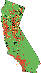
HHP dams are scattered across California, but tend to cluster around population centers (See map below). California provides a list of dams regulated by the state. The online list of dams does not include hazard classification. Dam safety officials can be contacted by phone at (916) 227-9800, by email at Dave.Gutierrez@water.ca.gov, or online through the DSOD home page.
A map showing the location of HHP dams is included in a summary of California dam statistics provided in the California section of the National Inventory of Dams (NID) compiled by the U.S. Army Corps of Engineers. This information is updated annually by state dam safety officials. If you can locate a HHP dam near an area where you live, work, travel or have recreational activities, it is important that the dam have an EAP. Since half of California HHP dams do not have EAPs it is a good idea to check on the status. The Citizen Action section of this website contains suggestions on urging or helping owners to complete EAPs.
When you know the county where a dam is located and a nearby town, using Geographic Information Systems (GIS) software such as Google Earth can often provide a "bird's eye view" of the area terrain. The website Lat-Long.com lists California dams and links locations to maps and satellite views. Using the map to zoom in on the impoundment and then the satellite image can provide more visual understanding of the terrain. Another helpful tool for determining whether an area is at risk is the North California Floodplain Mapping website.
 Red Dots= "High-hazard potential dam" is typically defined as a dam whose failure or mis-operation will cause loss of human life and significant property destruction.
 Yellow Dots = "Significant-hazard potential dam" is typically defined as a dam whose failure or mis-operation will cause significant property damage.
Black Dots = "Low-hazard potential dam" is typically defined as a dam whose failure or mis-operation will cause minimal property damage.
Knowing where a HHP dam is located that may impact your home, business, or favorite recreational area is important. But knowing the boundaries of the "hazard area" also is important. A thorough EAP will include an "inundation map" that shows the hazard area. Inundation maps have been completed for most large dams. Maps and EAPs are under the jurisdiction of the California Office of Emergency Services (CalOES) Dam Safety Program. California law code requires dam owners to submit copies of inundation maps developed by civil engineers to the CalOES. Owners of some small and/or rural dams may be allowed a waiver from the inundation mapping requirement by CalOES, or allowed to submit less detailed maps.
This is based on whether the effects of potential inundation in terms of death or personal injury, as determined through onsite inspection by CalOES in consultation with the affected local jurisdictions, can be ascertained without an inundation map, or where adequate evacuation procedures can be developed without benefit of an inundation map. If development occurs in any exempted area after a waiver has been granted, the local jurisdiction must notify CalOES of that development. All waivers must be reevaluated every two years by CalOES.
The CalOES Dam Safety Program coordinates with other state and federal agencies in activities to assure effective dam incident emergency response procedures and planning. The CalOES Dam Safety Program is also the designated repository of the official dam failure inundation maps used in California's Natural Hazard Disclosure Statement as specified in Civil Code § 1103 for real estate transactions. Copies of dam inundation maps are also provided to the appropriate public safety agency of any city and/or county likely to be affected. Most local agencies overlay these inundation maps onto their parcel map systems. CalOES provides a directory of local emergency managers to contact to determine what parcels are within inundation zones.
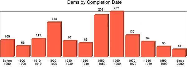
A major factor in concern about the need for EAPs is the age of many HHP dams. Hundreds of the dams are known to have been built prior to 1950, and the construction date for hundreds more is unknown.
Many dams become a greater hazard as they continue to age and deteriorate. While hundreds of them need to be rehabilitated, lack of funding prevents the work. Even dams that fall under state regulation can be a problem when ownership of the dam is unknown and rehabilitation is likely to be costly. The NID summary for California includes an overview of the age of the state's dams. Hundreds of dams built prior to the 1970s are past their design lifetime of 50 years, and development in their inundation zones may increase their hazard classification.

