Citizens Action
Ways to Plan Ahead
Know your risk. Do you live downstream from a dam? Is the dam a high-hazard or significant-hazard potential dam? To find out the hazard classification and owner of a dam, contact the Department of Water Division of Safety of Dams (DSOD). If DSOD does not regulate the dam, you may be able to find out if it is a Federal dam and contacts for the dam. To find out whether the dam has an EAP and the inundation zone below the dam, contact the California Office of Emergency Services (CalOES) Dam Safety Program. Your local Emergency Management Director also will be helpful. CalOES has posted a directory of EMDs.

Once you determine that you live downstream from a high-hazard or significant-hazard potential dam and find out who owns the dam, see if a current EAP is in place for the dam. An EAP is a formal document that identifies potential emergency conditions at a dam and specifies preplanned actions to be followed to reduce property damage and loss of life. An EAP specifies actions the dam owner should take regarding problems at the dam. It also includes steps to assist the dam owner in issuing early warning and notification messages to responsible downstream emergency management authorities.
If there is a dam failure or an imminent dam failure and you need to evacuate, know your evacuation route and get out of harm's way. In general, evacuation planning and implementation are the responsibility of the state and local officials responsible for your safety. However, there may be situations where recreational facilities, campgrounds, or residences are located below a dam and local authorities will not be able to issue a timely warning. In this case, the dam owner should coordinate with local emergency management officials to determine who will warn you and in what priority.
Sample
Innundation
Map
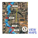
Inundation maps have been developed for most large dams. These maps and EAPs are under the jurisdiction of the California Office of Emergency Services (CalOES). California law requires dam owners to submit copies of inundation maps developed by civil engineers to the CalOES. Copies of these maps are also provided to the appropriate public safety agency of any city and/or county likely to be affected. Most local agencies overlay these inundation maps onto their parcel map systems. CalOES provides a directory of local emergency managers to contact to determine what parcels are within inundation zones.
CalOES is required by state law to work with other state and federal agencies, dam owners and operators, floodplain managers, planners, and the public to make available dam inundation maps for the benefit of citizens interested in learning their dam failure inundation risk. Local emergency managers and planners also find the maps useful in preparing Local Hazard Mitigation Plans (LHMPs).
The Department of Water Resources (DWR) has a Best Available Mapping (BAM) project in which the more accurate and detailed current floodplain maps statewide are being made digitally available to the public. These 100-, 200- and 500- year floodplain maps are available on a statewide basis for all counties in order to communicate flood risk hazards to property owners, flood risk managers, and land use planners. Through providing these maps in a user friendly format, DWR strives to facilitate better and more informed local and statewide planning decisions.
This current statewide BAM effort builds upon previous efforts, directed by Senate Bill 5 (2007) to develop maps for California's communities depicting 100- and 200- year floodplains for areas located within the Sacramento-San Joaquin Valley watershed. Data sets are being obtained from DWR, the Federal Emergency Management Agency (FEMA), the US Army Corp of Engineers, and regional studies. This is the first time in California that a compilation of flood maps from these agencies has been made available to the public. The 100-, 200-, and 500-year floodplains are displayed on a DWR web viewer at http://gis.bam.water.ca.gov/bam/.
Note of Caution: While the BAM maps will help you understand the flood risk for a particular parcel or neighborhood, BAM does not replace existing FEMA regulatory floodplains shown on Flood Insurance Rate Maps (FIRM). The BAM floodplains identify potential flood risks that may warrant further studies or analyses for land use decision making. The floodplains shown delineate areas with potential exposure to flooding for three different storm events: one with storm flows that have a 1% chance of being equaled or exceeded in any year (100-year), one with storm flows that have a 0.5% chance of being equaled or exceeded in any year (200-year), and one with storms flows that have a 0.2% chance of being equaled or exceeded in any year (500-year). These flows and resulting flooded area are based on the best available floodplain information and may not identify all areas subject to flooding.